Aerial Construction Progress Monitoring
Using drones to collect aerial data for site surveys can cut down the site survey process from 2-3 weeks into a matter of 2 days, one to collect the data and another to process it.
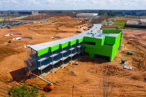
How To Conduct Construction Monitoring With Drones
UAS platforms provide speed and efficiency vs traditional ground surveying methods thanks to their ease of use and the rapid nature of their deployment to a site. Where a typical ground surveyor may take up to a day or more to survey a usual ground site a UAS platform can do so in a matter of hours. Not only is an aerial element able to circumvent many of the barriers found on ground level but is able to provide a more encompassing view of a worksite which can open further avenues of use from a single set of images. By pairing any of the available mapping software with any of the common UAS platforms in use (Mavics and Phantoms primarily) any worker on a site can take a highly detailed photo map of a site.
Quality and speed are the cornerstones of any construction project with the need to meet deadlines being vital to staying within budgetary and time margins. By employing aerial data during the planning of a project the manager will be able accurately see where/when materials are needed in a certain location and if said location needs more attention to properly remain on track. A good example of this is just before and following the laying of the foundation of a building, by having accurate aerial data of the location the architect will have a significantly easier and faster time in planning out the dimensions of said building without running into potential issues down the line.
Benefits & Uses of Construction Progress Tracking With Drones
 Flying sites weekly or bi-weekly allows the project team to stay up to date and improves team communication. Documentation obtained regular will also be a great basis to track progress each regular interval.
With weekly, bi-weekly, or monthly aerial captures of a site a project manager can observe how quickly or adequately a section or the entire site is coming along with regards to a timeline and can formulate with other site leads on potential improvements or report to the backers of the site itself that project is coming along on time. As has been mentioned, time is money and being on time with a project can save a great amount of money in the long run.
Safety of workers and the site itself are of paramount importance to any project manager and while proper safety measures on the ground and a general safety culture are highly effective at minimizing risk an aerial element can go that step further in ensuring minimal hazards on site. With daily and weekly flights a project-manager will be able to easily spot any potential hazards that could be unfolding on the work site and quickly move to correct and prevent them. For example, a structure or area of earth that is progressively leaning or moving outside of parameters could be cause for concern and can easily be spotted in images over time tracking changes throughout the site.
- Remotely Monitor Construction Progress
- Improved Stakeholder Communication
- Enhanced Subcontractor Management & Quality Assurance
- Inspect Safety Issues Remotely
- Easily Visualize and Share Information on Progress
- Improves Efficiency & Quality Control
- Advanced Oversight & Planning
- Faster Data Collection & Processing than Ground Surveys